Monday 24 March 2014

Port of Spain Field Excursion 22nd March, 2014

St Clair                                                    Belmont
The "wash out "Bridge
Recreation/Leisure/Social Interaction at King George V Park


Rada Community Cemetery


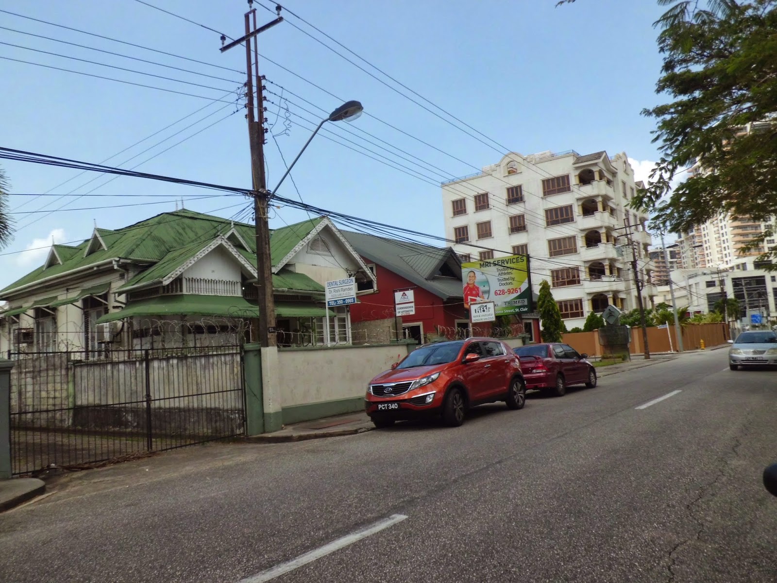
Building Architecture
the old and new


Art along Hayes Street

 The sun was blistering as the St. Clair group of geographers exited our maxi. Greeted by the snow cone man serving the King George V Park users we refused to be tempted. Not so for the driver! We set out along Hayes Street where anyone would appreciate the physical layout. Artwork depicting local culture, a park, people from various surrounding communities (having spoken to a few users), building architecture, old and new, colonial essence and contemporary design. Jane Jacobs would be in awe. We made our way through St Clair Avenue passing the residential houses behind well fenced walls. No people were seen on the roads! We came across a smaller park where there appeared to be residents however the collective group seemed intimidated and were unwilling to speak to the people in the park who appeared mostly white. We scuttled off, myself and one colleague disappointed by the missed opportunity for some inside information! Crossing Alexendra Street government and financial institutions,  and much diplomatic missions littered the area. We returned to Hayes Street passing the St. Clair Medical Centre at the end of our allotted time. With a birds view we noted the commercial businesses east of the King George V Park. The St. Clair district's planning is evident in its layout. It is no concrete jungle. Trees, shrubbery and small parks litter the landscape. Entertainment, recreation, leisure, utilities, schools, transportation, security, financial institutions as well as other services seem to be within reach of St. Clair residents.
 
First Financial Centre in Belmont


The journey started at the National Museum and Art Gallery on Frederick Street. Disappointed! Thought we were going to have a tour. A synopsis from Pre-Columbus to Independence were given by Mr Elton Scantlebury and Ms.Yvette Adams, our Belmont tour guides. Together we journeyed, a first for me, amiss of Belmont for crime headliners only. Mr Scantlebury painted a landscape of a community with a rich African heritage. We were made to see how that changed over time as urbanisation spread from the city centre to Belmont. First stop was the "wash out" bridge. Residents gathered here to wash clothes. Pipes were located along the man-made canal. This aspect of communal living have changed with the availability of a household water supply, wash tubs and washing machines. Mr Scantlebury who has done much work with the Free Town Foundation in the area, thinks the mentality of the people need to change in order for the community to rise from its current hapless state. Belmont's layout illustrates a lack of urban planning. The narrow roads are former tracks and the poor drainage system have caused much damage in recent years. In the 1940's Belmont had its first private housing scheme targeted at low income families. Terrence Mc Shine was the investor. Mc Shine was quite an entrepreneur as he championed the POS Charitable Brotherhood Friendly Society (1925), the first financial institution in Belmont. Lodges had meetings and community activities were also held at the location. At the Trinidad Theatre Workshop we encountered Ms Tyker Phillip, a resident who maintains that the community is still close knit, people demonstrate respect for each other and the residents are sociable. She pointed out that the Savannah was the main meeting ground for interaction and activities of a sociable and leisurely nature. Mas bands are an integral aspect of Belmont's heritage. We visited Glendon Morris Copper Works & Mas Camp where it was noted that the historical aspects of costume design (the Apache Indian and sailors) are no longer holding the interest of the mas players but "skimpy" two piece bikini outfits with much exposure of the body is what's selling. The historical aspects of Trinidad's Carnival is being lost to the demands of the international appeal. Our last Belmont stop was at the Rada Community Cemetery. This group of people, just over 100 populate the Belmont area with a spiritualism of their own. These non-slave African immigrants live and socialize with the other Belmont residents. The history is rich and there is much to be learnt. Its heritage  needs to be protected, as well as its most important resource, the people. Crime is at a high and social attention is needed in the area for existing delinquents and deterring others. The main infrastructural problem highlighted was the dire need for solutions to its drainage woes. It must be noted that the houses though old and run down in appearance were concrete structures. This indicated some wealth had to be present in the past to construct such structures. Jane Jacobs would be aghast.


 Jane Jacobs saw "good neighbourhoods" based on her categorisation, districts like St Clair. It had mixed uses: parks, residences, schools, businesses and on going activity, which she said creates a safer environment. Belmont on the other hand lacked parks, commercial businesses and on going activity as the environment is not safe for such, given the high concentration of crime. Jacobs thought "good neighbourhoods" had different buildings, old and new which supported architectural design and persons of varying income levels. Old and new were seen in St Clair however Belmont's buildings were all unkempt and dilapidated. The streets were also littered with garbage contrary to the clean St. Clair. Perhaps we did not walk enough to clearly establish if there were much alternative routes to any one destination in Belmont. Given the narrow unplanned paths and a few noted dead ends I would not be hopeful if I were Jacobs. St. Clair seemed to have a grid type design based on the few streets we walked through. Such Jacobs thought encouraged the social and economic aspects of a neighbourhood. She finally put forward that a high density population was stimulating for city life. Given the spatial distribution of residences in Belmont they would outnumber that of St. Clair. Based on the two areas I would have to disagree with Jacobs on this last point. Like Mr Scantlebury puts it, the people of Belmont need to change their mentality and this I think would stimulate city life with a difference. The other aspects of her principles are applicable and supports St. Clair to emerge as a " good neighbourhood".
 
Having looked at St. Clair and Belmont, I would say that St Clair seem to be more successful than Belmont as an urban neighbourhood. Its success is attributed to the time in which it was birthed. Planning took place before its design. The physical geography of the area was allotted its space for housing, schools, parks commercial businesses, roads, sidewalks and other basic necessary infrastructure for any community. Financial status also contributes to the well being of a neighbourhood. The ability to have financial power to spend and invest in contemporary society lends itself to increased, socialization and leisure activities, not limited to the community itself.
 
 
Reference: Urban Geog\Jane Jacobs Urban Ideas.htm (Cited on 24th March, 2014).


Monday 10 February 2014

Space, Place, Culture and Time.


National Academy for the Performing Arts (NAPA)
 From the eyes of the Morvant Hills, a panoramic view of the capital city of Trinidad and Tobago, the city of Port of Spain. At the centre of the photo is the National Academy for the Performing Arts (NAPA). The architectural masterpiece of the city centre was designed to promote local culture in particular, the national musical instrument, the steel pan. Lewis Mumford (1938) {page 3} would call this an "...academy of learning..." where he viewed the city as..."the form and symbol of an integrated social relationship..." NAPA will be a hub of activity for the upcoming Carnival season. This institution will draw to it a diversification of peoples and with them their cultures in art and theatre. NAPA, architecture with design and purpose, in contrast to the chaotic arrangement of building structures surrounding it. Aesthetics in the making, perhaps! It is a new space in the city which transcends the past and exudes a status of power. Shrubbery and trees have been attempted to be preserved in the medley.... for how long, will be seen in the spatial dynamics of urban progress. The following link gives details of its design, usefulness and contact information.


Housing for urban dwellers based on economic status
The distinction of spatial lines from afar, visually spells segregation of classes by housing in Port of Spain, Trinidad. The spatial arrangement of housing as seen above is expressive of income inequalities. The middle-class and poor on the outskirts and the wealthier upper-class closer to the core of the city centre. The type of housing varies as well; single family units, apartment buildings, condominiums, hotels as well as other types. Based on the spatial arrangement captured in the above photograph, Gideon Sjoberg (1960)'s Pre-industrial Society Urban Model reflects the same. The city of Port of Spain developed without much industrial influence and the elites are centred around their own Central Business Districts (CBD) (Alonso et al 1960). Based on the housing arrangements of neighbourhoods and property value, West Port of Spain are concentrated with the elites while East Port of Spain are cramped with the poor and unemployed. The following is a link to a newspaper article, highlighting recent politics at play, in dealing with unemployment and the types of neighbourhoods the unemployed were from. 


The Economics of Urban Space

The Eric Williams Financial Complex locally known as the twin towers of Port of Spain sit at the core of the city centre. Surrounded by commercial activity the administration of the country's economy is at the heart of this state institution. The distribution of resources for urban development have progressed haphazardly as state control have been inconsistent in the local democracy. The concept of urban planning is a new phenomenon being drafted into local policies for sustainable development in Trinidad and Tobago. A new government ministry have been set up for this: (http://www.planning.gov.tt/). Economic investment directs social patterns which translates into spatial arrangements. William Alonso's 1960's Monocentric City Model was centred on urban economics which focused on spatial relationships to understand the driving factors of city formation. Port of Spain's recent developments have been to attract the global audience for local tourism and investment; Carnival, The International Waterfront, Port Facilities, Inter-City Transportation, NAPA and Hotels to name a few.

The Power of the State

 Whether deliberate or not allowances by the state for developments of particular spaces in urban centres have seen such space become the "place" of different groups in society. The Jamaat-Al-Muslimeen occupying state lands in St James (http://guardian.co.tt/news/2012-04-30/muslimeen-member-claims-land-row-caused-attempted-coup), Movie Towne Shopping and Entertainment Complex, Zen Night Club, condominium apartments, parks and arenas. Society becomes constructed based on the segregation of people by religion, class, wealth, mobility and other such factors. Smith (1989) pointed out that such "development" leads to the exclusion of members of society. For the modernist such progress is championed as a new society and global culture infiltrates the locale, ebbing at the social rootedness and landscape continuity of the urban environment.


The Spatial Construction of Race

The above photograph is the famous "Library Corner" in the city of San Fernando, southern Trinidad, where a multiplicity of races cross paths. Historically marginalized groups have been socially excluded from institutions and welfare services. Trinidad and Tobago's colonial past has left a mentality along the same trend. Local political culture uses this divide to sway voters, gain power and imprint an image of racial segregation upon the urban population. The colour of one's skin or eyes and the texture of one's hair are unspoken determinants of one's place and ultimately the space in which they occupy. This may be through housing, work, recreation, leisure or transport, to name few. Susan J. Smith pointed out that already disadvantaged groups in society find themselves trapped in spaces, unable to progress with opportunities of urban growth. The racial divide is evident in construction design for conduct of social life in the urban. Take Port of Spain for instance the West has a clutter of parks and recreational grounds whereas the East has only the Queens Park Savannah to contend with for its leisure, recreation, entertainment and other socio-communal needs. (See the following map: http://www.undp.org.tt/TT-Today/images/maps/City-of-Port-of-Spain.jpg). The minority of elites: Whites, Syrians, Lebanese and fewer Asians of the West versus the majority of the East: the Black, poor, unemployed and middle-class, in terms of the Port of Spain population which urban development catered for.


Graffiti and Gang Warfare
 

Space becomes territorial when cultures and societal values clash. Graffiti is symbolic of identifying and creating territorial space. The graffiti depicted above is in Woodbrook, Port of Spain, and does not seem confrontational but serene and symbolic of local culture on a dilapidated building. If it was done on Hayes Street, St Clair, it might have been called art! Behind the design though is its true character; the "language of space for the street gang culture" (Ley 1974). Beyond this though the urbanization progress of Port of Spain have seen the growth of violent gangs moving from robberies and petty crime to a South American method of Warfare" (See the following article:
Rivalry between gangs for "turf" says the meaning of space changes, making its value assert behaviour. This urbanization phenomenon accounts for the majority of serious crimes in Trinidad and Tobago.


Spaces for Walking in an Urban Environment

Harris Promenade, San Fernando, a serene footpath to the alternative busy streets spanning the Library Corner to the San Fernando General Hospital. There are a number of shaded trees and benches utilized by commuters and vagrants alike. On alternate sides there are government institutions, the magistrates court, a police station, lawyers and other administrative services. Limited parking is available and an active wrecking service is in effect for the driving public willing to take chances. Jane Jacobs was an advocate for pedestrianized neighbourhoods in urban development. Parks, sidewalks and pavements are all public spaces important in maintaining the locale and continuity of the landscape for human social relations. Jacobs argued that streets were safer with more "eyes" on it when people walked to their destinations. Shorter streets with alternative routes was good she said for commercial businesses as well. The city of San Fernando is still somewhat a place of social rootedness, therefore preserving spaces for walking is an idea considered for reducing vehicular traffic into the city centre. Further to this attempts have been made to encourage the travelling public to utilize public transport however the idea has not embedded the minds of southerners just yet: (http://www.trinidadexpress.com/news/High-hopes-for-PTSC-Park-and-Ride-238979361.html).

 
Spaces for Parking in Urban Environments

Space is the abstraction of places into a grid or coordinate system. It is also thought of as commanded or controlled. Parking in urban environments can be challenging, competitive, stressful and costly. This street along Harris Promenade in San Fernando accommodates the working class of early morn. The culture of typical Trinidadians aspire to owning a motor vehicle. It speaks of independence, privacy and an upward move of one's status. There are over one million registered vehicles in Trinidad and Tobago (http://www.trinidadexpress.com/business-magazine/Too-many-cars-226076551.html). The idea of multi-storey car parks are slowly being engineered in urban development in Trinidad. Such design transcends the past by demand. The landscape for parking must change or alternative means of transportation in and out of urban centres need urgent address.  Some first world nations have sought to develop strategies to ease traffic congestion in their urban environments which is worthy of note: http://www.internationaltransportforum.org/jtrc/infrastructure/congestion/CongestionSummary.pdf.
 
The Commerce of Street Space
Street space for commercial activity whether it be clothes, fruits and vegetables, doubles, snow cones or cotton candy is flavourful to the Trinidadian culture. Pedestrian mall owners are always lobbying for the removal of street vendors in urban areas throughout Trinidad and Tobago. The above photograph is a hotspot for bargains on High Street, San Fernando. Rubenstein (1992) states that streetscapes and open urban spaces "create an image for the city in which they are located". He went further to add that "they are a meeting place and a centre for various activities that improve the physical and social environment". Such commercial activity adds to the competitiveness of business and affords consumers a variety of choice based on their spending powers. The mixed use of urban spaces in Trinidad is somewhat radical and accommodating to the working class or people on the go. The state is always at the centre of "turf" war between shop owners and street vendors. The street vendor is fighting for survival and gets public sympathy even though the shop owner is doing the same: (https://guardian.co.tt/news/2013-12-26/sando-businesses-being-strangled-street-vendors).


Green and Serene

Urban planners, more so in recent time have recognised the need for ecological preservation in urban development. The above photo was taken of the Queens Park Savannah in Port of Spain, Trinidad. A quiet time of day perhaps, it's usually abuzz with activity. The park offers relaxation and leisure; a get away from the chaos of the central business areas of work and activity. How sustainable is this space in aiding the rest of the city? On a global scale, not much! Rees (1992) work brings to the fore an understanding of the demands of urban environments on other geographical areas for sustenance exceeding the carrying capacity of the city itself. Through trade exploitation of poorer nations natural resources are capitalised upon. Striving for sustainability and natural resource preservation is the only assurance of the continuity of the human species. Trinidad and Tobago seem to still be planning their way forward in dealing with the global problem: http://www.planning.gov.tt/mediacentre/documents/working-sustainable-development-trinidad-and-tobago.


Reflection on other Blogs:
The above link's entry on the utilization of space for parking, walking and economic business serves to compound the dynamism of the changing urban environment as regard to the use of space. The picture is of a wide street, an exception by comparison to narrower streets in the grid design city with narrow pavements and no room for expansion of roads for driving. Changing the use of such space to a more pedestrianized environment perhaps, may be something to consider in the future!
 
The above link's entry on pollution shows the ugly side of urbanization. Pollution is a health hazard to humans and an ecological problem as it degrades the environment and threatens existing natural resources. Underground aquifers in Port of Spain for instance are at high risk for contamination. The pictures of garbage and other pollutants are the responsibility of the state for collection, however the residents of such communities can secure their garbage, call in the Port of Spain City Corporation as well as be more proactive themselves instead of choosing to have their space in such squalor!

The above link's entry on "The Life of the Party" demonstrates how "space" becomes one's "place". Social relations are nurtured and one's culture becomes defined. Human interaction is important and entrepreneurs have recognised the importance of such. Clubs, bars, restaurants, public transport hubs and other such places of urban areas cater to the need for communal relation between people not necessarily familial in the traditional sense but in the modern world friends and acquaintances in a greater sense.

 
References:
  • Alonso, W., Muth, R. and Mills, R. (1964), The Monocentric City Model.
  • Cloke, P.; Crang, P.; Goodwin, M. (1999) Introducing Human Geographies. Oxford University Press Inc.
  • Jacobs J. http://urbanspacegallery.ca/exhibits/jane-jacobs-urban-ideas/jane-jacobs-urban-ideas
  • Ley, D. (1974)The black inner city as frontier outpost: images and behaviour of a Philadelphia neighbourhood. Association of American Geographers.
  • Mumford, L. (1938) The culture of cities; Harcourt Brace and Company.
  • Rees, W. E. (1992)SAGE Social Science Collections. Environment and Urbanization, Vol. 4, No. 2, October 1992.
  • Rubenstein, H. M. (1992) Pedestrian Malls, Streetscapes, and Urban Spaces 1992 John Wiley and Sons Inc.
  • Sjoberg, G. (1960): http://gideonsjoberg.weebly.com/pre-industrial-theory.html.
  • Smith, S. J. (1989) The politics of race and residence. Cambridge: Polity Press.